There are various factors you must consider when flying a drone. One of those factors is its altitude. In case you don’t know, drone altitude limitations may exist in your area based on federal restrictions. So, you’ll be limited to a certain altitude. Various units are used to report and interpret altitude numbers. Prominent among those units are AGL and MSL. As you can tell from their initials, they’re different. Hence, we’ll pit AGL vs MSL in a bid to explain the differences between them and how they affect their usage.
Sometimes, you’ll need to use AGL, other times, MSL will be the better choice, so you must understand how both units work. In this article, we’ll dig deep into the workings of AGL and MSL, thus helping you to understand how to interpret your drone altitude perfectly.
AGL Altitude
You’ve probably been itching to know what AGL stands for. The acronym stands for Above Ground Level. Simply put, that’s the altitude measured from the ground below. No doubt, AGL is a commonly used unit in aviation and that tells that it’s quite important. Your drone’s altimeter uses AGL values when flying near its takeoff point.
Thanks to the AGL altitude, a drone pilot can tell how far away the ground is but that doesn’t always work. If the drone flew too far away from the takeoff point, you could have trouble determining the AGL altitude. Pilots of manned aircraft typically coordinate with air traffic facilities to determine the altitude but a drone pilot doesn’t have that luxury.
One significant disadvantage of the AGL altitude is its sole reliance on the altitude of a specific reference point which may deceive drone pilots that their machine is flying clear of obstacles.
MSL Elevation
MSL means Mean Sea Level or more correctly, Above Mean Sea Level. As the name suggests, MSL altitude values are measured against the sea level. Hence, it remains a constant value without any regard for the terrain you are flying over.
Of course, the sea level throughout the world is not exactly constant. However, the sea level’s universally accepted value was derived by studying the short-term and seasonal variations of tides over 19 years.
Also, the atmospheric pressure is measured above standard sea level to calibrate altitude. Hence, MSL provides the effects of atmospheric conditions on your drone’s flight performance.
Drone Flight AGL Altitude vs MSL Elevation
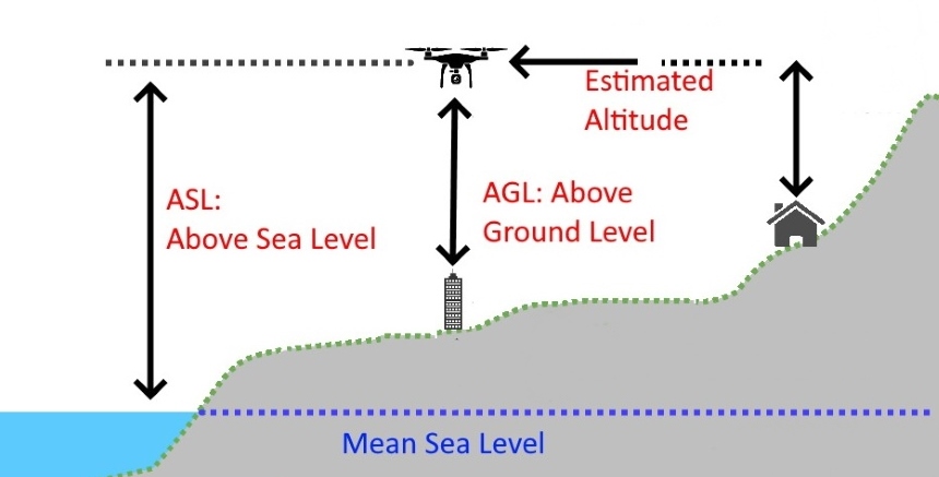
For example, if you’re on the roof of a 50-foot tall building, you’re at 50 feet AGL. However, if a building is at 100 feet MSL, it doesn’t necessarily mean that it’s 100 feet tall. Can you tell the difference here? While a building at 50 feet AGL means the building is 50 feet tall, the logic doesn’t apply for MSL. Rather, MSL deals with the sea level.
Don’t be surprised to learn that a 100-foot tall building is at 150 feet MSL. That only means that the land it is built on is located 50 feet above mean sea level. With this understanding, you can easily convert MSL to AGL.
Moreover, MSL is considered to be a more reliable unit when flying a drone over areas with carried terrain because AGL can quickly change if you’re flying over mountains and hills with varying heights. Also, AGL only works accurately when the drone’s altitude is relatively low. However, MSL works well even in very high altitudes. So, drone pilots typically switch to MSL in such cases.
Questions to consider
Let’s treat a couple of questions that simplify the difference between AGL and MSL below:
Question 1
You get on an elevator from the ground floor of your 100-foot tall office building and it takes you right to the roof. What can you say about this? Obviously, you’re at 100 feet AGL because you’re 100 feet above the ground below you.
Question 2
You’re standing on the roof of a 150-foot apartment building that is at 180 feet MSL. What can you say about it at the first attempt? Since the ground in which the building is located is at 180 feet MSL and the building itself is 150-foot tall, you’re at 330 feet MSL.
AGL to MSL Conversion
AGL (Above Ground Level) and MSL (Mean Sea Level) are two different ways of measuring altitude. To convert AGL to MSL and MSL to AGL, you need to know the elevation of the ground at your location. Here’s how to do it:
- Determine the ground elevation at your location: This information can be found using a topographic map or by using an app or website that provides elevation data.
- Add the ground elevation to your AGL altitude: The sum of the ground elevation and your AGL altitude will give you your MSL altitude. For example, if the ground elevation is 5000 feet and your AGL altitude is 1000 feet, your MSL altitude would be 6000 feet.
It’s important to note that AGL and MSL are not interchangeable and serve different purposes. AGL is used for evaluating obstacles or terrain relative to the drone’s altitude, while MSL is used to reference a standard elevation based on the average sea level.
Part 107 License

Before you can receive the license/certificate, you’ll need to complete the Part 107 Small UAS Initial (ALC-451) online training course. The course requires you to understand the operating requirements, regulations, and procedures (including AGL and MSL) for safely flying drones.
If you need relatively cheap drones, you can get the perfect option among the best drones under $600. Most reviews also suggest that the Ruko F11Gim Drone is a pretty impressive one thanks to the 4K camera with 2-Axis gimbal stabilization and the two intelligent batteries that offer a total of 56 minutes of flight time.
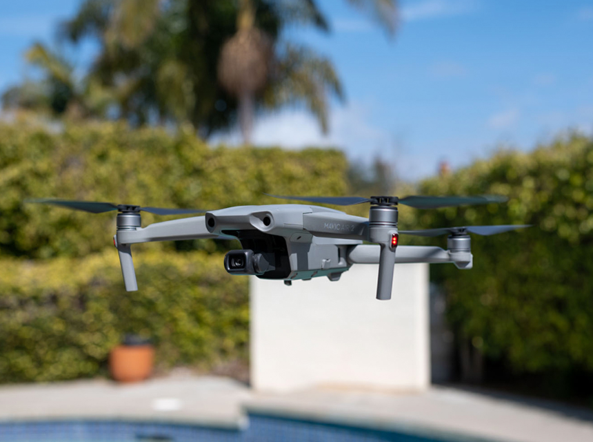
Or if you don’t mind spending more than $1000 on a drone that offers more functions and reliability, the DJI Mavic 2 Zoom Drone seems like the ideal choice. Offering a 1/2.3-inch 12MP sensor with up to 4x zoom, omnidirectional obstacle sensing, hyperlapse, adjustable aperture, 31 minutes flight time, and more, this drone can well be every pilot’s dream.
Final Thoughts
As a commercial drone pilot, you must know the difference between altitude values told in AGL and MSL because that helps you safely fly your drones. It also keeps you from going past altitude limits put in place by authorities. For example, the FAA’s maximum allowable altitude Trusted Source Fact Sheet – Small Unmanned Aircraft Systems (UAS) Regulations (Part 107) www.faa.gov is 400 feet above the ground. This is also the case in the United Kingdom per the country’s aviation regulator Trusted Source Please find below details of the CAA Publication you have selected. Dependent on availability, you are able to download the file, or purchase a printed copy. www.caa.co.uk .
Besides, in comparing AGL vs MSL, you can tell that the former’s value is limited based on altitude but MSL offers a more accurate value regardless of altitude or terrain. Notwithstanding, both units are important and you should understand them if you’re piloting the best drones for roof inspections or even the best drones for fishing.


